As the first record of Sextons in the parish of Castlehaven is the reference to Tim Sexton and Cors (Cornelius/Con) Sexton in the Tithe Applotment Book of 1825, we might safely assume that these two men were brothers who were born about 1765 and died about 1835. There was also at least one sister, Mary. Whether their father (probably a John Sexton) was the first Sexton in the parish may never be known but, if he was, he possibly settled there as a tenant farmer in the mid 1700s.
Tim held land in both Toehead and in Scobaun in 1825 while Con held a separate farm in Scobaun. The landlords for the townland of Scobaun were the French family of Cuskinny, Cobh while the Townshend family of nearby Castletownshend were landlords in Toehead.
Mary either married James Leary in 1821 (James being a neighbour who leased land with the Sextons in Glasheenaulin) or else was married to a Horan man and had at least one son, Tim Horan (1833-1917)]. This needs to be checked as one or both of these Marys may be a sister of another generation.
Toehead (Ceann Tuaithe)
Farming in Toehead in the early 19th century was organised under the old ‘rundale’ system with about a dozen families having access to small fields (the infield) that surrounded the collection of houses (sometimes called a clachan) that made up the settlement at the centre of the Toehead townland. Poorer quality fields further out (the outfield) were used for communal grazing of cattle. It is possible that poor quality land in the neighbouring townland of Gortacrossig was also used for summer grazing of cattle in a practice sometimes referred to as ‘booleying’. Each family had anything between eight and twenty acres. Tim Sexton’s immediate neighbours in Toehead were Burkes, Sweeneys and Keohanes while other neighbours were three families of Croneens (Cronin), Sheehanes (Sheehan) – two families, Sullivans, Dwyers, Catherganes (Cahalane?), Cains (Keane), Wests, Hourihanes, Hollands and Hurleys.
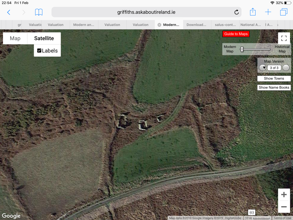
Picture shows Sexton houses at the southern end of Toe Head, well south of the main clachan. The ruins actually date from the post-famine era as they are not indicated on the 6-inch OS map from the early 1840s. The area shown in the picture is pretty much the entire Sexton holding and may have supported two families. Immediately to the south is the area known as the Móin Rua (the Red Bog), a boggy area that stretches south to the sea and faces out over the Stags Rocks.
Scobaun (An Scoth Bán)
By the early 19th century, farming in Scobaun was already being re-organised under a more ‘modern’ system where, in general, each farmstead (or perhaps two or three) was surrounded by its own patch of land – usually anything between seven and twenty three acres. Along with the two Sexton holdings, other farms were held by Sullivans (two familes), Hourihanes (three families), Henrys (three families) and Driscolls (one family).
Gortacrossig (Gort a’ Chrosaigh) and Glasheenaulin (An Glaisín Áilinn)
Land in the neighbouring townland of Gortacrossig was held by Sextons (probably the two Sexton brothers, Tim and Con) and by Burkes, Sullivans, Brahers and Sweeneys. Land was also held jointly by Sextons and Learys in the townland of Glasheenaulin a little to the east of Scobaun. This was a mixture of good quality tillage land and poor quality rough grazing and this land may have been an outlying farm held by one of the Sexton families of Scobaun
Those who were lucky enough to hold land paid an annual rent to the landlord and tithes that ranged between 10 shillings and a little less than £2. There were doubtless many other less fortunate families who eked out a living as labourers on the margins. We have no idea of the names of these families as, by 1850, they were gone, having been entirely entirely wiped out by the great famine of 1845-48. It is quite possible, indeed likely, that there were other Sexton families in this category.